My parents chide me crazy to give up a cozy job as Regional Human Resource Director for a MNC Company. Instead choose to lead Philanthropic lifestyle, often organising "Causes Campaign" in humanitarian welfare for the poverty stricken areas internationally.
Often characterised by my close friends as
An Explorer with the mindset of an Adventurer. Born to be wild and ever-ready jumping OFF THE BEATEN TRACK exploring and adventuring the unchartered destinations.
A semi-pro Photographer equipped with Certification as a DIVE MASTER, occasionally free-lance with NATIONAL GEOGRAPHIC.
TRAINING
1983 - Singapore Armed Forces (Reconnaissance Officer) / Trained in Combat Survival & Para Medic Course
1986 - Mount Rainier National Park Rescue Team (During my University Vacation)
2001 - Singapore Red Cross Society Major Disaster Crisis Management Team Leader
ACHIEVEMENTS
1981 - Mount Ophir (1,276m)/ Mount Fansipan (3,142m) / Mount Kinabalu (4,095m)
1982 - Mount Rinjani (3,726m)
1986 - Langtang Trek, Nepal (4,984m)
1988 - Mount Kilimanjaro Lemosho Trek, Barafu Camp (5,895m) + Serengeti Safari
1989 - Mount Kilimanjaro Machame Trek, Barafu Camp (5,895m) + Udzungwa Mountains Trek
1990 - Annapurna Base Camp (8,091m)
1991 - Everest Base Camp, South Base Camp (5,364m)
1992 - Everest Base Camp, North Base Camp (5,150m)
1992 - Tibet, Mount Kailash Kora, Dira Puk (4,775m)
1993 - Corsica GR20, France (2,183m)
1994 - Inca Trail, Peru (3,660m)
1995 - Baltoro Glacier & K2 (8,611m), Pakistan
1996 - The Narrows, USA (2,800m)
1997 - The Haute Route, France-Switzerland (2,743m)
1998 - Inca Trail, Peru
1999 - Pays Dogon, Mali, West Africa
2000 - Overland Track, Australia
2001 - Routeburn Track, New Zealand
MOST MEMORABLE TREKS
Corsica GR20, France
This demanding 15- day (168km, 104mi) slog through Corsica is legendary for the diversity of landscapes it traverses.
There are forests, granite moonscapes, windswept craters, glacial lakes, torrents, peat bogs, maquis, snow-capped peaks, plains and névés (stretches of ice formed from snow).
But it doesn’t come easy: the path is rocky and sometimes steep, and includes rickety bridges and slippery rock faces – all part of the fun.
Created in 1972, the GR20 links Calenzana, in the Balagne, with Conca, north of Porto Vecchio.
Inca Trail, Peru
This 33km (20mi) ancient trail was laid by the Incas and is currently traversed by thousands each year. The trail leads from the Sacred Valley to Machu Picchu winding its way up and down and around the mountains, taking three high passes en route.
Views of white-tipped mountains and high cloud forest combine with the magic of walking from one cliff-hugging ruin to the next – understandably making this South America’s most famous trail.
Pays Dogon, Mali, West Africa
‘The land of the Dogon people’ is one of Africa’s most breathtaking regions. A trek here can last anywhere between two and 10 days, and takes in the soaring cliffs of the Bandiagara escarpment inlaid with old abandoned cliff dwellings. Dogon villages dot the cliffs and are an extraordinary highlight of the journey.
The Dogon are known for their masked stilt dancers, intricately carved doors and pueblo-like dwellings built into the side of the escarpment.
Everest Base Camp
Reaching a height of 5,545m (18,193ft) at Kala Pattar, this three-week trek is extremely popular with those who want to be able to say, ‘I’ve been to the base of the world’s highest mountain’.
The difficult trek passes undeniably spectacular scenery and is trafficked by Sherpa people of the Solu Khumbu.
The heights reached during this trek are literally dizzying until you acclimatise to the altitude, and the continuous cutting across valleys certainly has its ups and downs.
Indian Himalayas, India
Fewer folk trek on the Indian side of the world’s greatest mountain range. So, if isolation’s your thing, try trekking in Himachal Pradesh.
Hardcore hikers can try teetering along the mountain tops for 24 days from Spiti to Ladakh. This extremely remote and challenging walk follows ancient trade routes. The bleak high-altitude desert terrain inspired Rudyard Kipling to exclaim, ‘Surely the gods live here; this is no place for men’.
Overland Track, Australia
Tasmania’s prehistoric looking wilderness is most accessible on the 80km (50mi, five- to six-day) Overland Track.
Snaking its way between Cradle Mountain and Lake St Clair (Australia’s deepest natural freshwater lake), the well-defined path (boardwalked in parts) passes craggy mountains, beautiful lakes and tarns, extensive forests and moorlands.
Those who want more can take numerous side walks leading to waterfalls, valleys and still more summits including Mt Ossa (1,617m, 5,305ft) – Tassie’s highest.
Routeburn Track, New Zealand
See the stunning sub-alpine scenery of New Zealand’s South Island surrounding this medium three-day (32km, 20mi) track.
At the base of New Zealand’s Southern Alps, the track passes through two national parks: Fiordland and Mt Aspiring.
Highlights include the views from Harris Saddle and atop Conical Hill – from where you can see waves breaking on the distant beach.
The main challenge for this popular hike is actually securing a place among the limited numbers who are allowed on the track at any time.
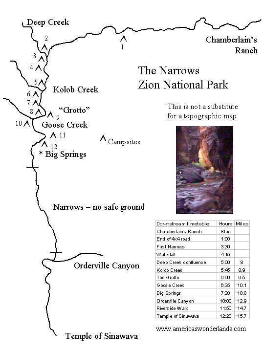
The Narrows, USA (2,800m)
A 26km (16mi) journey through dramatic canyons carved over centuries by the Virgin River, the Narrows in Zion National Park is a hike like no other.
The route is the river, with over half of the hike spent wading and sometimes swimming.
The hike can be traversed in a day, though some choose to take the hanging gardens and natural springs at a more leisurely pace – spending a night at one of the park’s 12 camp grounds.
The Haute Route, France-Switzerland (2,743m)
Leading from Chamonix in France through the southern Valais to Zermatt in Switzerland, the Haute Route traverses some of the highest and most scenic country accessible to walkers anywhere in the Alps.
The summer Haute Route walk (which takes a different course than the more famous winter skitouring route) takes around two weeks to complete.
It mainly involves ‘pass hopping’ and demands a high level of fitness, with every section containing a high huff factor.
Baltoro Glacier & K2 (8,611m), Pakistan
This corridor of ice leads to the colossal peak of K2 (8,611m, 28,251ft), the world’s second-highest peak. This incomparable trek traverses some of the most humbling scenery on the planet.
What begins following icy rivers boldly goes to the guts of the glacier before leading to the granite pyramidal mountains including
Paiju (6,610m, 21,686ft)
Uli Biaho (6,417m, 21,053ft)
Great Trango Tower (6,286m, 20,623ft)
K2
The peak has now been climbed by almost all of its ridges. Although the summit of Everest is at a higher altitude, K2 is a much more difficult and dangerous climb, due in part to its more inclement weather and comparatively greater height from base to peak. The mountain is believed by many to be the world’s most difficult and dangerous climb, hence its nickname “the Savage Mountain.” It, and the surrounding peaks, have claimed more lives than any others. As of July 2010, only 302 people have completed the ascent, compared with over 2,700 individuals who have ascended the more popular target of Everest. At least 80 (as of September 2010) people have died attempting the climb. Notably, 13 climbers from several expeditions died in 1986 in the 1986 K2 Disaster, five of these in a severe storm.
More recently, on August 1, 2008, a group of climbers went missing after a large piece of ice fell during an avalanche taking out the fixed ropes on part of the route; four climbers were rescued, but 11, including Gerard McDonnell, the first Irish person to reach the summit, were confirmed dead. On August 6, 2010, Fredrik Ericsson, who intended to ski from the summit, joined Gerlinde Kaltenbrunner on the way to the summit of K2. Ericsson fell 1,000 metres (3,300 ft) and was killed. Kaltenbrunner aborted her summit attempt.
The major routes to have been climbed on the south side of the mountain.
A: West Ridge
B: West Face
C: Southwest Pillar
D: South Face
E: South-southeast Spur
F: Abruzzi Spur
Almost opposite from the Abruzzi Spur is the North Ridge, which ascends the Chinese side of the peak. It is rarely climbed, partly due to very difficult access, involving crossing the Shaksgam River, which is a hazardous undertaking. In contrast to the crowds of climbers and trekkers at the Abruzzi basecamp, usually at most two teams are encamped below the North Ridge. This route, more technically difficult than the Abruzzi, ascends a long, steep, primarily rock ridge to high on the mountain — Camp IV, the “Eagle’s Nest” at 7,900 metres (25,900 ft) — and then crosses a dangerously slide-prone hanging glacier by a leftward climbing traverse, to reach a snow couloir which accesses the summit.
Besides the original Japanese ascent, a notable ascent of the North Ridge was the one in 1990 by Greg Child, Greg Mortimer, and Steve Swenson, which was done alpine style above Camp 2, though using some fixed ropes already put in place by a Japanese team.
For most of its climbing history, K2 was not usually climbed with bottled oxygen, and small, relatively lightweight teams were the norm. However the 2004 season saw a great increase in the use of oxygen: 28 of 47 summiteers used oxygen in that year.
Acclimatisation is essential when climbing without oxygen to avoid some degree of altitude sickness. K2′s summit is well above the altitude at which high altitude pulmonary edema (HAPE), or high altitude cerebral edema (HACE) can occur, above the 8000-metre altitude that marks the boundary of the “death zone.”
K2 North Pillar
If the 15 days doesn’t floor you, take side trips to more moraine-covered glaciers.


